THE HUMAN IMPACT
Not Miles Away.
Just Feet From Our Community.
Some depictions of the proposed Sentinel Green Fig Project Forge data center make the property appear isolated, surrounded by little more than open space.
But what those images don't show is what's just a few hundred, or even a few dozen, feet away.
Families raising children. Babies napping at daycare. Kids playing on swings. Students living and learning on campus. Neighbors walking their dogs. Seniors enjoying retirement. People gathering for worship.
These aren't distant communities. It's our home.
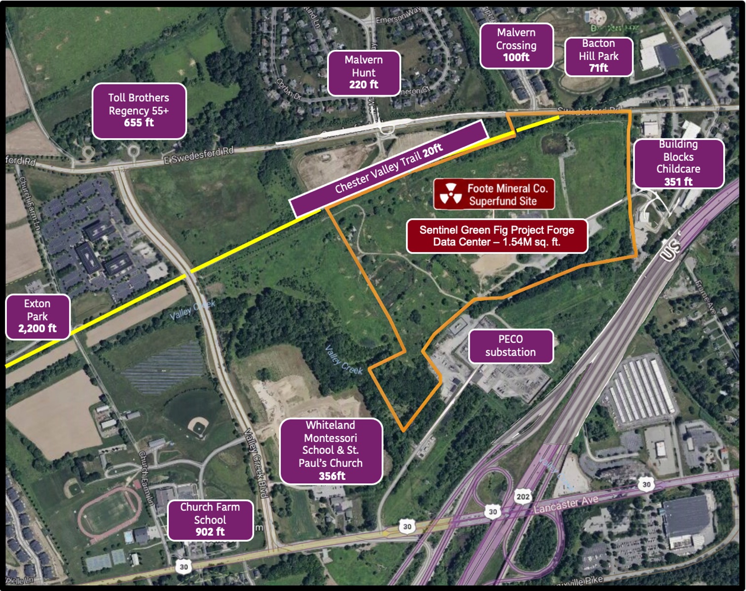
Just Feet From Our Community
The distances tell the story. The people behind them matter.
Chester Valley Trail
Bacton Hill Park
Malvern Hunt
Malvern Crossing
Building Blocks Childcare
Whiteland Montessori School & St. Paul's Episcopal Church
Regency at Valley Creek 55+
Church Farm School
Exton Park Playing Fields
The People Behind the Distances
Click any location to see why it matters.
Chester Valley Trail20 ft
A beloved community trail where families walk, cyclists ride, runners exercise, and wildlife thrives. Just feet separate this treasured public space from the proposed development.
Bacton Hill Park71 ft
Where children swing, run, play, and make childhood memories.
Malvern Hunt220 ft
An established neighborhood home to 279 households, where families have built their lives.
Malvern Crossing100 ft
A community of 66 households along Piper Lane, where neighbors have put down roots.
Building Blocks Childcare351 ft
Where infants and young children spend their days being cared for, learning, and playing outdoors.
Whiteland Montessori School & St. Paul's Episcopal Church356 ft
Where children learn and grow, and neighbors come together in faith and fellowship.
Regency at Valley Creek 55+655 ft
A growing community where residents are enjoying retirement and building their next chapter.
Church Farm School902 ft
Where young men live, learn, form friendships, and prepare for their futures.
Exton Park Playing Fields~2,200 ft
Where children play sports, families cheer from the sidelines, and neighbors gather as a community.
Hear an example of data center noise
This looping recording illustrates sound from a data center in Northern Virginia. It is not a recording or prediction of Project Forge. A 60 dBA level is provided for general noise context only; the recording has not been calibrated to play at 60 dBA, and its actual loudness depends on your device and volume settings.
The Distance Between Decisions and Daily Life
East Whiteland Board of Supervisors
Their homes are, on average, 1.91 miles from the proposed Project Forge site.
Sentinel Data Centers CEO
Resides in a state with a statewide data center moratorium.
Green Fig Managing Partner
Resides in a township where preservation is a priority and open space is protected by an active land conservation trust.
The Foote Mineral Superfund Site
The former Foote Mineral property remains on the EPA's Superfund National Priorities List.
Contamination from the site rendered nearby private drinking-water wells unusable.
The EPA's 2024 review identified unresolved questions about the lateral and vertical extent of groundwater contamination.
VOCs are emitting from the site, raising ongoing environmental concerns.
Current lithium concentrations at monitoring wells at the site were documented at ~550 times EPA's cleanup target.
Don't Be Fooled by Google Search Results.
A Google search for the Foote Mineral Superfund site may lead to an EPA page stating that site activities have concluded.
That Is Misleading.
The EPA statement that “activities at this site have concluded” refers to the completion of a particular phase of remedial work, not the completion of the site's cleanup or a determination that the contamination has been fully addressed.
EPA continues to evaluate groundwater contamination and determine what additional actions may be necessary to achieve the site's cleanup goals.
Here Is the Real Site Status.
| Human Exposure Under Control | Insufficient Data |
| Groundwater Migration Under Control | No |
| Construction Complete | Yes |
| Sitewide Ready for Anticipated Use | No |
The EPA's 2024 Five-Year Review also deferred a determination of whether the cleanup remedy is protective of human health and the environment.
The Contaminated Soil Is Still ON SITE.
The EPA directed that the most heavily contaminated soil be moved into the former quarry areas of the Foote Mineral property, where it was consolidated and covered to create an area known as “The Cap.” The contaminated soil was never removed from the property.
The Cap is subject to institutional controls and a 2017 Environmental Covenant. The Cap cannot be disturbed. The documented parcel covers 12.026 acres, and the cap is approximately 12 feet high.
The Cap is directly adjacent to the proposed Project Forge data center buildings and equipment. The soil contains more than 20 contaminants.
Documented parcel area
Approximate cap height
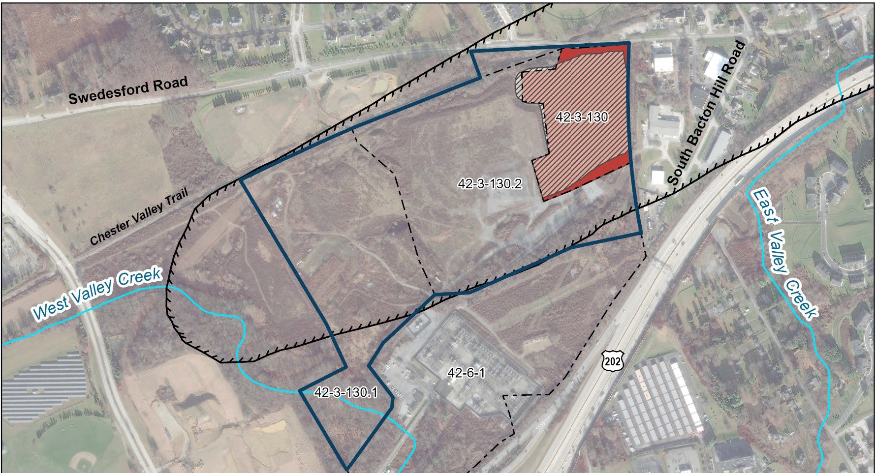
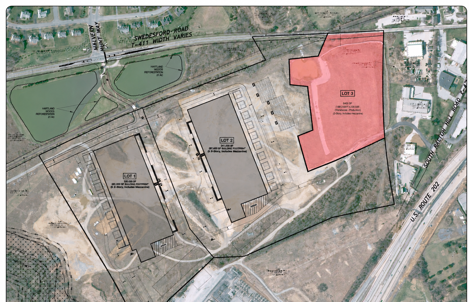
The Contamination Isn't Somewhere Else. It's Right There.
The proposed data centers would be built immediately beside a capped area containing contaminated soil.
What Is the True Cost to the Community?
$53–99 million in ANNUAL health-related damages
Dr. Michael Cork of EmPower Analytics Group estimated health-related damages from permitted emissions associated with on-site power generation at a Loudoun County data center.
This estimate concerns a Virginia facility, not Project Forge.
Lackawanna County, Pennsylvania, hired Cork's EmPower Analytics Group to assess cumulative air-quality and public-health impacts from proposed data centers and power plants, an initiative covered by The New York Times.
Read about Lackawanna County's independent study ↗
The True Financial Impact
A fiscally responsible evaluation should account for projected revenue and potential costs borne by the community.
Where Is East Whiteland's Fiscal Due Diligence?
Lackawanna County officials have commissioned independent research into the potential health and environmental costs of data center development. Has the East Whiteland Board of Supervisors conducted a similarly rigorous, independent assessment of Project Forge's full fiscal impact, including potential health and environmental costs, tax incentives, and property value losses?
Residents deserve to know whether the projected revenue outweighs the costs the community may be left to bear.
Unanswered Questions. Missing Accountability.
The community has unanswered questions about the site's cleanup, the potential health and environmental impacts of Project Forge, and the full economic consequences for nearby residents.
These questions deserve independent analysis, public transparency, and clear answers from those responsible for evaluating the project.
We may be missing from the renderings. But we're not miles away. We're right here.
And we matter.
East Whiteland United
Measurement note: Distances shown correspond to the locations identified on the accompanying East Whiteland United aerial map. They represent approximate straight-line distances to the relevant Project Forge property boundaries, based on Chester County GIS parcel data.